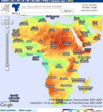
Photovoltaic Geographical Information System (PVGIS)
 Geographical Assessment of Solar Resource and Performance of Photovoltaic Technology.
Photovoltaic Geographical Information System (PVGIS) provides a map-based inventory of solar energy resource and assessment of the electricity generation from photovoltaic systems in Europe, Africa, and South-West Asia. It is a part of the SOLAREC action that contributes to the implementation of renewable energy in the European Union as a sustainable and long-term energy supply by undertaking new S&T developments in fields where harmonization is required and requested by customers.
Launch PVGIS Africa
ECOWAS Observatory for Renewable Energy and energy Efficiency
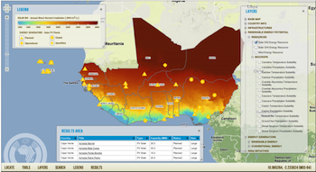 The ECOWAS Observatory for Renewable Energy and energy Efficiency is aimed at improving existing knowledge and mitigating information barriers towards the development of the energy sector in the ECOWAS region.
ECOWREX provides decision makers, project developers, investors and other stakeholders with tailored information and planning strategies. It will boost knowledge management, networking, advocacy and strengthening of capacities on renewable energy and energy efficiency. provide over 40 different layers related to energy resources and other infrastructure relevant for planning, in the energy sector. Users can query and search by well structured attributes, overlay and analyze these resources together.
Click the map image above to explore the Observatory GIS Viewer.
Launch ECOWAS Map Viewer


")